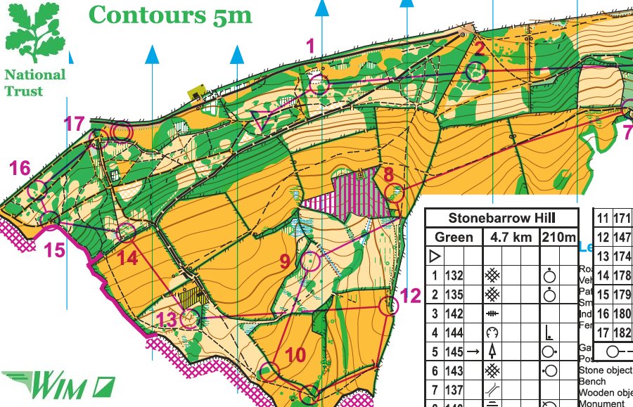
Stonebarrow Hill
Dorset Schools and Informal event, Saturday 28 March 2015
Results
On Saturday we had a fantastic event at Stonebarrow near Charmouth. A brand new map drawn by Mike Kite who was also the Organiser and Controller and excellent planning by Tamsin Horsler making good use of the area. Thanks to both of them for all their hard work and to all the other WIM members who helped out during the day.
The weather was interesting at times but did not affect the many adults and juniors who turned up to enjoy themselves.
We must also thank the National Trust and Ranger - Sarah Kennedy - for all the help that we were given in putting on this event.
Mike Kite now has future plans to combine the Stonebarrow and Golden Cap maps to make a much larger area - so you never know - it could be a future Galoppen event.
Chris Branford
Part of the Green course
Mapping data licenced from the Ordnance Survey with the permission of the Controller of HMSO. Crown Copyright 2009.
All rights reserved. Licence Number 100015287.
Many thanks to everyone for helping make this event so successful despite the weather. As Chris remarked, 'The clag made it even better and meant that you had to navigate.' Tamsin's courses were much appreciated: it was nice to see some newcomers enjoying getting soaked on White & Yellow, and there was universal applause for Green, slightly muted by the ascent from the coast path! A pleasure, as always, to work with the crack WIM team.
About a dozen people asked me when I was going to join up the two maps. I seem to have replied with groundless enthusiasm....
Mike Kite
A Tale of Two Maps - or maybe Three
Golden Cap was the first and Stonebarrow the second major map I've drawn. West Dorset has an awful lot of contours and both areas were difficult though in different ways. Learning the hard way on Golden Cap, making hundreds of mistakes, was valuable training for my next venture.
Both areas were mapped using Ocad 8. I've experimented with the free OpenOrientering Mapper (OOM) program, but settled on 'standard' software for compatibility with mappers & planners I might consult about critical details. I had also discovered Lidar while mapping Golden Cap and saw it as essential for Stonebarrow. Proper Lidar integration requires Ocad 11 but I could make jpeg contour images from Lidar data using QGIS, a free GIS program, so Ocad 8 would do the job OK.
When I began to survey and map Golden Cap in 2013, I chose Ordnance Survey 1:25k Pathfinder as the initial basemap. There were two reasons: it shows contours at 5m intervals, and I have the digital 'Memory Map' version on my PC.
Although OS Pathfinder is ideal for map reading at 1:25,000, I soon found it lacks enough precision at large scales. I was surveying at 1:2,500 for a map designed to be read at 1:7,500. Oversimplified contours and fuzzy images just weren't up to the job. I therefore incorporated OS MasterMap (their flagship vector product) as a second basemap and, later on, tailor-made Lidar contour jpegs. They became the core templates.
Learning from this, on Stonebarrow I started off with OS MasterMap and integrated it with a 5m Lidar contour image before surveying & mapping began. Positioning both basemaps so they fitted exactly was fiddly and time consuming but once it was done I had two first class templates. I was able to survey and map accurately at large scales without continually making adjustments to try and match generalised 1:25k raster data. It was much faster and more accurate than Golden Cap.
Google maps & Bing aerial photos were also used, especially when drawing vegetation features. They had been helpful in mapping open areas on Golden Cap; on Stonebarrow they were invaluable for getting the hugely complicated gorse & bramble patches exactly right. Usually I made a template by taking screenshots and stitching them together, then experimenting with trial-and-improvement dpi (dots per inch) imports until I had a perfect fit.
So on to the next task - combining the two maps! They're 600m apart at their closest point but the straight line distance along the SW Coast Path is 1.2km so there's a lot in between. Symbols & sizes were also individually customised and will need harmonising. Just to start things off nicely, I discovered that the colour palette index for Golden Cap had for some unknown reason mutated on 29 January. It took several hours to figure out why I couldn't merge maps (the new version defaulted to the original index) and then how to build a usable colour index manually. In new territory again.
At last though, it's underway! Looks like a busy time ahead....
Mike Kite
Relative locations of the Stonebarrow and Golden Cap maps
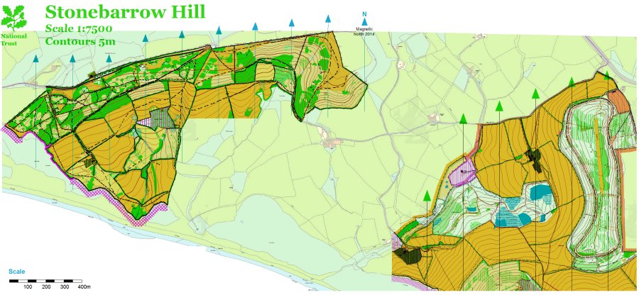
Background photo from Stonebarrow looking towards Langdon Hill (left), Golden Cap
and St Gabriel's valley.
Portland is just visible across Lyme Bay.
